
High-Risk Days From 2000-2003: |
||
| This
page contains all the days on which a high risk of severe
thunderstorms has been forecast from January 01, 2000 up through
2003. The next page contains all high risk days from 2004 up to the
present day. I am still adding additional events. To the best of my knowledge there are no dates missing in this time set. Beau Dodson |
||
| April 06, 2001: A classic southern plains (Tornado Alley) spring tornado outbreak was forecast, a squall line producing a derecho (a widespread thunderstorm high wind event) developed instead over parts of Kansas and Oklahoma. Because of the lack of tornadoes, this day was frustrating to chasers even though it was not technically a bust because widespread severe weather did occur. | ||
| Archived NSSFC Products | Storm Chaser Accounts | Other Links |
|
0600 UTC Day 1 Outlook (1:00 AM CDT) Public Severe Weather Outlook #1 (5:00 AM CDT) 1300 UTC Day 1 Outlook (8:00 AM CDT) 1630 UTC Day 1 Outlook (11:30 AM CDT) Public Severe Weather Outlook #2 (12:00 PM CDT) 2000 UTC Day 1 Outlook (3:00 PM CDT) Storm Reports Weather Maps From NCEP April 05-07 - Weather Maps Radar Images NCDC Radar Images April 06-07 More Products From SPC SPC Storm Reports Composites: Surface & Upper Air Parameters Surface Analyses: HPC Synoptic Scale Upper Air Analyses: 925mb: 12Z 00Z 850mb: 12Z 00Z 700mb: 12Z 00Z 500mb: 12Z 00Z 300mb: 12Z 00Z 250mb: 12Z 00Z Skew-T/Log-P Plots Image Loops: Total Area Center: MO SFC RAD SAT SPC Products: Day 1 Outlooks: 0600Z 1300Z 1630Z 2000Z 0100Z Mesoscale Disc. Watches |
Shane Adams Jim Bishop and Simon Brewer Scott Blair Dorian Burnette Bob Conzemius David Drummond Charles Edwards "INCHASE" Indiana Storm Chasers Justyn Jackson (Note-all the links to SPC watches and discussions are outdated) Aaron Kennedy - Missing Jeff Lawson Don Lloyd "Louisiana Delta Chasers" Eric Nguyen Chris Nuttall Jason Politte-Page 1 Page 2 Robert Satkus Dean Schoeneck Matt Sellers Jason Sippel - Missing Jeff Wear |
Historical Weather Maps (Viewing the Daily weather maps requires the free Djvu Browser Plug-In) |
| April 11, 2001: Outbreak of mostly small, but fast-moving tornadoes in Iowa. Northern Illinois and southern Wisconsin were included in the high risk zone at one point, but I was not aware of it because I did not know about the SPC's online convective outlooks until 2002. Good thing, too, because the Wisconsin and Illinois parts of the high risk busted, with only isolated reports of high winds. | ||
| Archived NSSFC Products | Storm Chaser Accounts | Other Links |
|
1300 UTC Day 1 Outlook (8:00 AM CDT) 1630 UTC Day 1 Outlook (11:30 AM CDT) 2000 UTC Day 1 Outlook (3:00 PM CDT) Storm Reports Weather Maps From NCEP April 10-12 - Weather Maps Radar Images NCDC Radar Images April 11-12 More Products From SPC SPC Storm Reports Composites: Surface & Upper Air Parameters Surface Analyses: HPC Synoptic Scale Upper Air Analyses: 925mb: 12Z 00Z 850mb: 12Z 00Z 700mb: 12Z 00Z 500mb: 12Z 00Z 300mb: 12Z 00Z 250mb: 12Z 00Z Skew-T/Log-P Plots Image Loops: Total Area Center: IA SFC RAD SAT SPC Products: Day 1 Outlooks: 0600Z 1300Z 1630Z 2000Z 0100Z Mesoscale Disc. Watches |
Chris Gullikson Mike Hollingshead - Missing "INCHASE" Indiana Storm Chasers-Page 1 Page 2 Don Lloyd Stan Olson Jeff Snyder Scott Weberpal |
Historical Weather Maps (Viewing the Daily weather maps requires the free Djvu Browser Plug-In) La Crosse, WI NWS Summary Warning process during the outbreak-AMS Conference paper |
| June 11, 2001: Derecho over parts of Minnesota and Wisconsin. The second time my location was in a high risk this year, the second time I was oblivious to it, and the second time I saw nothing more than an ordinary thunderstorm. A high risk, while certainly a serious weather situation that warrants close attention, is far from a guarantee that you will be hit by severe weather! | ||
| Archived NSSFC Products | Storm Chaser Accounts | Other Links |
|
0600 UTC Day 1 Outlook (1:00 AM CDT) 2000 UTC Day 1 Outlook (3:00 PM CDT) Missing 0100 UTC Day 1 Outlook (8:00 PM CDT) Storm Reports Weather Maps From NCEP June 10-12 - Weather Maps Radar Images NCDC Radar Images June 11-12 More Products From SPC SPC Storm Reports Composites: Surface & Upper Air Parameters Surface Analyses: HPC Synoptic Scale Upper Air Analyses: 925mb: 12Z 00Z 850mb: 12Z 00Z 700mb: 12Z 00Z 500mb: 12Z 00Z 300mb: 12Z 00Z 250mb: 12Z 00Z Skew-T/Log-P Plots Image Loops: Total Area Center: MI SFC RAD SAT SPC Products: Day 1 Outlooks: 0600Z 1300Z 1630Z 2000Z 0100Z Mesoscale Disc. Watches |
Charles
Edwards Rory Groves Don Lloyd - Missing Jeff Snyder |
Historic Weather Maps Second Set (Viewing the Daily weather maps requires the free Djvu Browser Plug-In) Wikipedia Article Green Bay, WI NWS Summary AMS Conference paper-derecho-induced storm surge CIMSS Case Study University Of Wisconsin Study - PDF Alex Lamers' essay |
| October 13, 2001: Not much known about this day. The outlook was upgraded from MDT to HIGH at 2000Z, then downgraded to SLGT at 0100Z. A spatially very concentrated tornado outbreak occurred in the immediate Gulf Coastal region of Florida and Alabama. | ||
| Archived NSSFC Products | Storm Chaser Accounts | Other Links |
|
2000 UTC Day 1 Outlook (3:00 PM CDT) Storm Reports Weather Maps From NCEP October 12-14 - Weather Maps Radar Images NCDC Radar Images October 13-14 More Products From SPC SPC Storm Reports Composites: Surface & Upper Air Parameters Surface Analyses: HPC Synoptic Scale Upper Air Analyses: 925mb: 12Z 00Z 850mb: 12Z 00Z 700mb: 12Z 00Z 500mb: 12Z 00Z 300mb: 12Z 00Z 250mb: 12Z 00Z Skew-T/Log-P Plots Image Loops: Area Center: MS SFC RAD SAT SPC Products: Day 1 Outlooks: 0600Z 1300Z 1630Z 2000Z 0100Z Mesoscale Disc. Watches |
AMS Conference paper - Missing |
Historic Weather Maps Second Set (Viewing the Daily weather maps requires the free Djvu Browser Plug-In) |
| October 24, 2001: 2001 was the first of two years in a row with a potent fall storm system producing an extensive combination tornado outbreak/derecho from the Ohio Valley to the Southeast. | ||
| Archived NSSFC Products | Storm Chaser Accounts | Other Links |
|
0600 UTC Day 1 Outlook (1:00 AM CDT) Public Severe Weather Outlook #1 (4:30 AM CDT) 1300 UTC Day 1 Outlook (8:00 AM CDT) 1630 UTC Day 1 Outlook (11:30 AM CDT) Public Severe Weather Outlook #2 (11:30 AM CDT) 2000 UTC Day 1 Outlook (3:00 PM CDT) 0100 UTC Day 1 Outlook (8:00 PM CDT) Storm Reports Weather Maps From NCEP October 23-25 - Weather Maps Radar Images NCDC Radar Images October 24-25 More Products From SPC SPC Storm Reports Composites: Surface & Upper Air Parameters Surface Analyses: HPC Synoptic Scale Upper Air Analyses: 925mb: 12Z 00Z 850mb: 12Z 00Z 700mb: 12Z 00Z 500mb: 12Z 00Z 300mb: 12Z 00Z 250mb: 12Z 00Z Skew-T/Log-P Plots Image Loops: Area Center: KY SFC RAD SAT SPC Products: Day 1 Outlooks: 0600Z 1300Z 1630Z 2000Z 0100Z Mesoscale Disc. Watches |
Shane Adams John Farley Stan Olson Dan Robinson Richard Thies |
Historic Weather Maps (Viewing the Daily weather maps requires the free Djvu Browser Plug-In) Lincoln, IL NWS Summary Nashville, TN NWS Summary Paducah, KY NWS Summary St. Louis, MO NWS Summary Syracuse, IN NWS Summary Wilmington, OH NWS Summary Midwestern Regional Climate Center Case Study AMS Conference paper Video Wikipedia Article |
| April 16, 2002: Bust. Major derecho was forecast to develop in the northern Plains and track into the upper Mississippi Valley. It never happened as only a few isolated severe storms developed. There were actually more severe storms in the southern Plains (where most of the people listed below chased) in the SLGT risk area than there were in the HIGH risk. | ||
| Archived NSSFC Products | Storm Chaser Accounts | Other Links |
|
0600 UTC Day 1 Outlook (1:00 AM CDT) Public Severe Weather Outlook #1 (5:15 AM CDT) 1300 UTC Day 1 Outlook (8:00 AM CDT) 1630 UTC Day 1 Outlook (11:30 AM CDT) Public Severe Weather Outlook #2 (1:00 PM CDT) 2000 UTC Day 1 Outlook (3:00 PM CDT) Storm Reports Weather Maps From NCEP April 15-17 - Weather Maps Radar Images NCDC Radar Images April 16-17 More Products From SPC SPC Storm Reports Composites: Surface & Upper Air Parameters Surface Analyses: HPC Synoptic Scale Upper Air Analyses: 925mb: 12Z 00Z 850mb: 12Z 00Z 700mb: 12Z 00Z 500mb: 12Z 00Z 300mb: 12Z 00Z 250mb: 12Z 00Z Skew-T/Log-P Plots Image Loops: Area 1 Center: OK SFC RAD SAT Area 2 Center: NE SFC RAD SPC Products: Day 1 Outlooks: 0600Z 1300Z 1630Z 2000Z 0100Z Mesoscale Disc. Watches |
Shane Adams Jim Bishop and Simon Brewer Dorian Burnette Bob Conzemius Charles Edwards Jon Garner Mike Hollingshead Damon Hynes "Minnesota Storm Intercept Association" Putnam Reiter Chad Ringley - Missing Robert Satkus - Missing Jeff Snyder |
Historic Weather Maps (Viewing the Daily weather maps requires the free Djvu Browser Plug-In) |
| July 31, 2002: Another forecasted upper Mississippi Valley derecho event busts. Only isolated severe wind and hail occurred. | ||
| Archived NSSFC Products | Storm Chaser Accounts | Other Links |
|
0600 UTC Day 1 Outlook (1:00 AM CDT) Public Severe Weather Outlook (6:39 AM CDT) 1300 UTC Day 1 Outlook (8:00 AM CDT) Storm Reports Weather Maps From NCEP July 30-August 01 - Weather Maps Radar Images NCDC Radar Images July 31 More Products From SPC
Storm
Reports
Surface
Analyses
Upper
Air
925mb:
12Z 00Z
850mb: 12Z 00Z 700mb: 12Z 00Z 500mb: 12Z 00Z 300mb: 12Z 00Z 250mb: 12Z 00Z Skew-T/Log-P Plots
Image
Loops
SPC
Products
|
Jim
Bishop and Simon Brewer -No write-up, just a photo. Jeff Snyder |
Historic Weather Maps (Viewing the Daily weather maps requires the free Djvu Browser Plug-In) |
| November 10, 2002: For the second year in a row a powerful fall storm system triggers a major tornado outbreak/derecho event in the Ohio Valley and southeastern states. Included the infamous Van Wert, Ohio (F4)and Mossy Grove, Tennessee (F3) tornadoes. | ||
| Archived NSSFC Products | Storm Chaser Accounts | Other Links |
|
0600 UTC Day 1 Outlook (12:00 AM CST) Public Severe Weather Outlook #1 (4:00 AM CST) 1300 UTC Day 1 Outlook (7:00 AM CST) 1630 UTC Day 1 Outlook (10:30 AM CST) Public Severe Weather Outlook #2 (1:10 PM CST) 2000 UTC Day 1 Outlook (2:00 PM CST) 0100 UTC Day 1 Outlook (7:00 PM CST Storm Reports Weather Maps From NCEP November 09-11 - Weather Maps Radar Images NCDC Radar Images November 10-11 More Products From SPC SPC Storm Reports Composites: Surface & Upper Air Parameters Surface Analyses: HPC Synoptic Scale Upper Air Analyses: 925mb: 12Z 00Z 850mb: 12Z 00Z 700mb: 12Z 00Z 500mb: 12Z 00Z 300mb: 12Z 00Z 250mb: 12Z 00Z Skew-T/Log-P Plots Image Loops: Total Area Center: TN SFC RAD SAT Area 1 Center: OH SFC RAD Area 2 Center: TN SFC RAD Area 3 Center: MS SFC RAD SPC Products: Day 1 Outlooks: 0600Z 1300Z 1630Z 2000Z 0100Z Mesoscale Disc. Watches Additional Maps: 1 2 3 4 5 |
Ben Cotton Colin Davis Justyn Jackson Mirror Page Amos Magliocco Dan Robinson |
Historic Weather Maps Second Set (Viewing the Daily weather maps requires the free Djvu Browser Plug-In) Birmingham, AL NWS Summary Greenville/Spartanburg, SC NWS Summary (Adobe PDF) Jackson, MS NWS Summary Louisville, KY NWS Summary Nashville, TN NWS Summary Paducah, KY NWS Summary Syracuse, IN NWS Summary Wilmington, OH NWS Summary "'Bama Weather" Reports & Surveys Additional documentation of this event from a Great Lakes and Toledo, Ohio website Van Wert, Ohio Tornado Video Van Wert, Ohio Tornado Video Van Wert, Ohio Tornado Video Van Wert, Ohio Tornado Video Logan Ohio Tornado Warning Video Storm Stories Wikipedia Article |
| December 23, 2002: Localized tornado outbreak in southeast Texas. No fatalities. | ||
| Archived NSSFC Products | Storm Chaser Accounts | Other Links |
|
0600 UTC Day 1 Outlook (12:00 AM CST) Weather Maps From NCEP December 22-24 - Weather Maps Radar Images NCDC Radar Images December 23-24 More Products From SPC
Storm Reports
Surface Analyses
Upper Air
925mb:
12Z 00Z
850mb: 12Z 00Z 700mb: 12Z 00Z 500mb: 12Z 00Z 300mb: 12Z 00Z 250mb: 12Z 00Z Skew-T/Log-P Plots
Image Loops
SPC Products
|
Historic Weather Maps Second Set (Viewing the Daily weather maps requires the free Djvu Browser Plug-In) Houston/Galveston, TX NWS Summary (Adobe PDF, scroll down to "December" entry and to the later "Severe Weather Events" entry) |
|
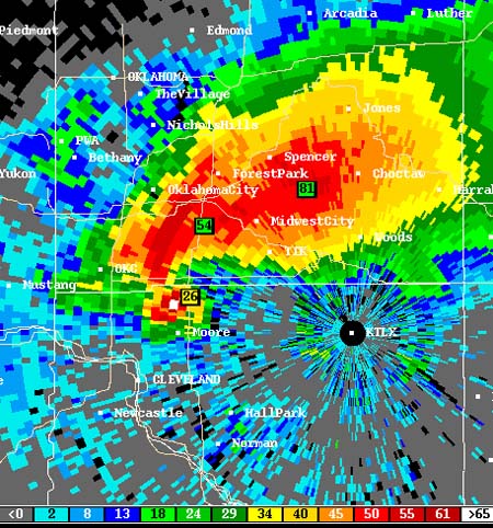
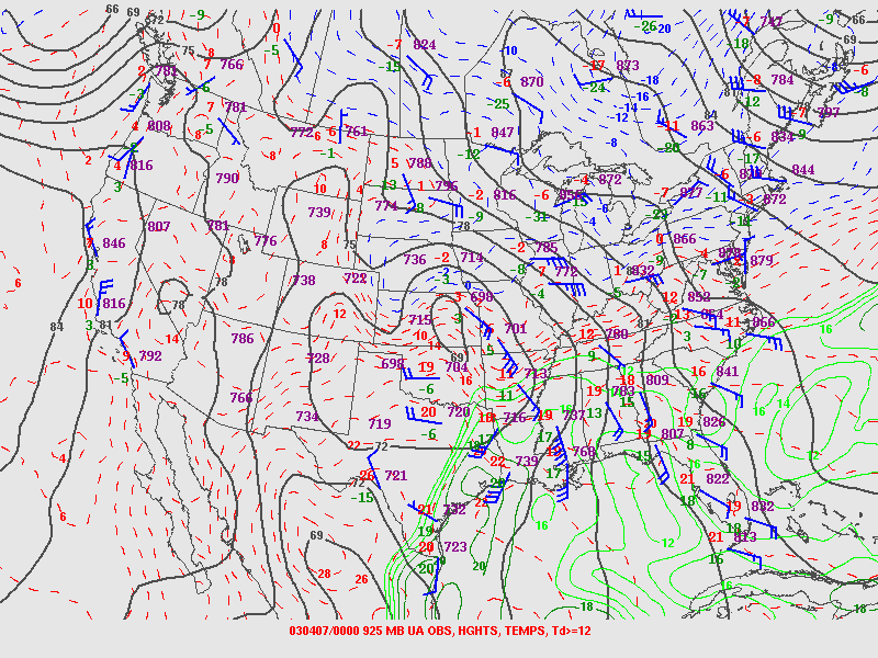
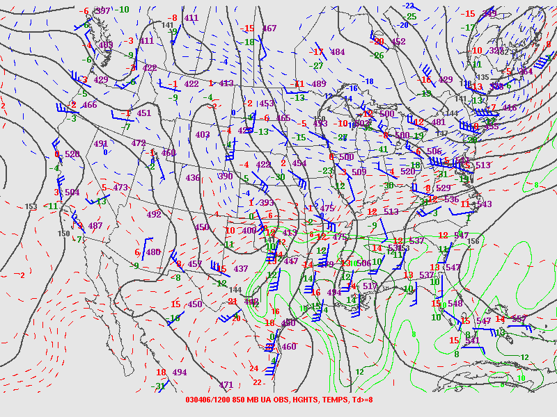
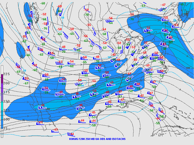
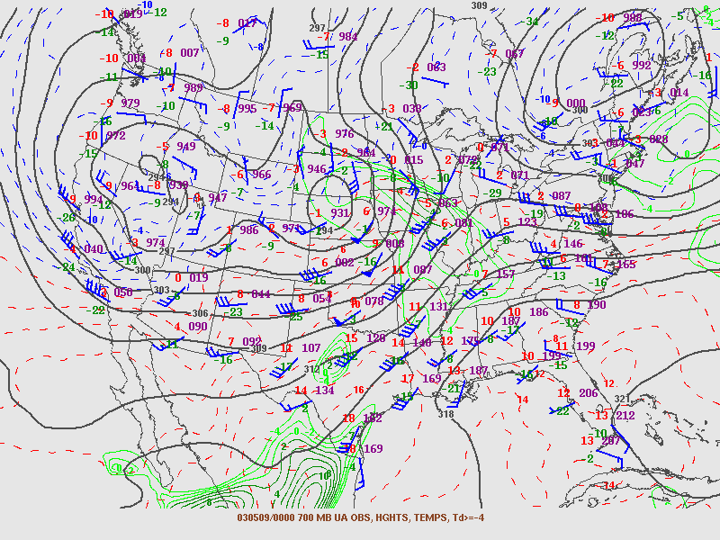
| April 06, 2003: Localized tornado outbreak from Mississippi westward to east Texas. | ||
| Archived NSSFC Products | Storm Chaser Accounts | Other Links |
| Day 1 Convective Outlooks:
2003/day1otlk_20030406_010 (April 5th 7 PM) 2003/day1otlk_20030406_1200 2003/day1otlk_20030406_1300 2003/day1otlk_20030406_1630 2003/day1otlk_20030406_2000 Storm Reports Day 2 Convective Outlooks: 2003/day2otlk_20030406_0800 2003/day2otlk_20030406_1730 Weather Maps From NCEP April 05-07 - Weather Maps Radar Images NCDC Radar Images April 06-07 More Products From SPC
Storm Reports
Surface Analyses
Upper Air
925mb:
12Z 00Z
850mb: 12Z 00Z 700mb: 12Z 00Z 500mb: 12Z 00Z 300mb: 12Z 00Z 250mb: 12Z 00Z Skew-T/Log-P Plots
Image Loops
SPC Products
|
David
Drummond Jon Garner Justyn Jackson "Louisiana Delta Chasers" Robert Satkus Brian Thalken Ben Vassmer Kevin Walter |
Historic Weather Maps Jackson, MS NWS Summary Shreveport, LA NWS Summary |
| May 04, 2003: Major tornado outbreak centered on eastern Kansas and western Missouri. Produced several infamous killer tornadoes, including Girard, Kansas, Pierce City/Battlefield, Missouri, and Kansas City, Kansas/Missouri. Many of these tornadoes approached a mile wide and were rated F3 or F4. | ||
| Archived NSSFC Products | Storm Chaser Accounts | Other Links |
|
2003/day1otlk_20030504_1200 2003/day1otlk_20030504_1300 2003/day1otlk_20030504_1630 2003/day1otlk_20030504_2000 Storm Reports Day 2 Convective Outlooks: 2003/day2otlk_20030504_0800 2003/day2otlk_20030504_1730 Weather Maps From NCEP May 03-05 - Weather Maps Radar Images NCDC Radar Images May 04-05 More Products From SPC
Storm Reports
Surface Analyses
Upper Air
925mb:
12Z 00Z
850mb: 12Z 00Z 700mb: 12Z 00Z 500mb: 12Z 00Z 300mb: 12Z 00Z 250mb: 12Z 00Z Skew-T/Log-P Plots
Image Loops
SPC Products
|
Shane Adams Charles Allison Jim Bishop and Simon Brewer Dorian Burnette Bob Conzemius Bill Doms David Drummond Charles Edwards John Farley Gabe Garfield Jon Garner Shawn Hewitt Roger Hill - Missing Mike Hollingshead Bernard Hulshof Damon Hynes Scott Kampas Aaron Kennedy - Missing Douglas Kiesling Dave Lewison Don Lloyd Amos Magliocco Steve Miller - Missing Chris Nuttall and Kyle Mozley - Missing Michael Peregrine - Missing Jason Politte Page 1 Page 2 Andrew Revering Karen & Gene Rhoden Chad Ringley - Missing Chris Sanner Robert Satkus Dean Schoeneck "Silver Lining Chase Tours"/David Gold Jeff Snyder Mike Umscheid Ben Vassmer Jeff Wear Peggy Willenberg and Melanie Metz |
Historic Weather Maps Kansas City, MO NWS Summary Little Rock, AR NWS Summary Memphis, TN NWS Summary Paducah, KY NWS Summary Springfield, MO NWS Summary Missing Wichita, KS NWS Summary NOAA article Girard, Kansas Tornado Video Tornado Video Kansas City Tornado Video Kansas City Tornado Video Girard, Kansas Tornado Video Kids Playing While Tornado Approaches Kansas City KMBC 9 Tornado Damage Video Battlefield, Missouri Tornado Video Parkville, Missouri Tornado Video Wikipedia Article |
| May 05, 2003: Relatively small (by comparison to the other outbreaks this incredible week) outbreak of tornadoes and severe thunderstorms in the southeastern states. | ||
| Archived NSSFC Products | Storm Chaser Accounts | Other Links |
|
Day 1 Convective
Outlooks:
2003/day1otlk_20030505_0100
(May 4th 7 PM) 2003/day1otlk_20030505_1200 2003/day1otlk_20030505_1300 2003/day1otlk_20030505_1630 2003/day1otlk_20030505_2000 Storm Reports Day 2 Convective Outlooks: 2003/day2otlk_20030505_0800 2003/day2otlk_20030505_1730 Weather Maps From NCEP May 04-06 - Weather Maps Radar Images NCDC Radar Images May 05-06 More Products From SPC
Storm Reports
Surface Analyses
Upper Air
925mb:
12Z 00Z
850mb: 12Z 00Z 700mb: 12Z 00Z 500mb: 12Z 00Z 300mb: 12Z 00Z 250mb: 12Z 00Z Skew-T/Log-P Plots
Image Loops
SPC Products
|
Nick Grillo (removed broken link) Mike Hollingshead-Did not chase high risk, but got a neat "catch" anyway! Dan Robinson-Missing - Says MDT risk day but was upgraded to HIGH at 1630 UTC (11:30 AM CDT) |
Historic Weather Maps Nashville, TN NWS Summary Wikipedia Article |
| May 08, 2003: Outbreak of fast-moving tornadoes in eastern Kansas, plus the infamous "Moore, Oklahoma Violent Tornado Mark II", an F4 which followed a very similar path to the F5 of May 03, 1999. It caused major damage but luckily no fatalities. | ||
| Archived NSSFC Products | Storm Chaser Accounts | Other Links |
|
Day 1 Convective Outlooks:
2003/day1otlk_20030508_0100
(May 7th 7 PM) 2003/day1otlk_20030508_1200 2003/day1otlk_20030508_1300 2003/day1otlk_20030508_1630 2003/day1otlk_20030508_2000 Storm Reports Day 2 Convective Outlooks: 2003/day2otlk_20030508_0800 Weather Maps From NCEP May 08-09 - Weather Maps Radar Images NCDC Radar Images May 08-09 More Products From SPC
Storm Reports
Composites
Surface Analyses
925mb:
12Z 00Z
850mb: 12Z 00Z 700mb: 12Z 00Z 500mb: 12Z 00Z 300mb: 12Z 00Z 250mb: 12Z 00Z Skew-T/Log-P Plots
Image Loops
Total Area:
Center TN- SFC RAD SAT Area 1: Center ARG-: SFC RAD Area 2: Center OK: SFC RAD Area 3: Center IAD: SFC RAD
SPC Products
|
Simon Brewer Dorian Burnette Bob Conzemius Dave Crowley - Missing David Drummond Charles Edwards Jon Garner Bernard Hulshof Justyn Jackson - Missing Douglas Kiesling Dave Lewison Don Lloyd - Missing Amos Magliocco Kevin McGrath Melissa Moon - Missing Eric Nguyen Ben Prusia - Missing Putnam Reiter - Missing Karen & Gene Rhoden Chad Ringley - Missing Dan Robinson Robert Satkus Paul Schlatter Dean Schoeneck Jeff Snyder Brian Thalken Ben Vassmer - Missing Jeff Wear |
Historic Weather Maps Louisville, KY NWS Summary Norman, OK NWS Summary Topeka, KS NWS Summary Wichita, KS NWS Summary - Missing Wikipedia Article |
| May 10, 2003: The Quad Cities area where Iowa, Illinois and Missouri intersect was hit hardest today in this outbreak when severe storms lined up along both major river valleys in the Midwest-the Mississippi Valley and the Ohio Valley. Amazingly no one was killed on a day that produced almost as big an outbreak as the 4th. At the end of the day the high risk extended to just south of the WI/IL border, but a couple of the supercells tracked into Wisconsin and spawned two tornadoes, one in Iowa County and one in Lafayette County. Both damaged some trees and outbuildings and were rated F1. One of them caused one injury. This was the end of this incredible week of endless tornado outbreaks (large outbreaks occurred on the other days even though they were not high risk days). | ||
| Archived NSSFC Products | Storm Chaser Accounts | Other Links |
|
Day 1 Convective
Outlooks:
2003/day1otlk_20030510_0100
(May 9th 7 PM) 2003/day1otlk_20030510_1200 2003/day1otlk_20030510_1300 2003/day1otlk_20030510_1630 2003/day1otlk_20030510_2000 Storm Reports Day 2 Convective Outlooks: 2003/day2otlk_20030510 2003/day2otlk_20030510 0800z 2003/day2otlk_20030510 1730z Weather Maps From NCEP May 09-11 - Weather Maps Radar Images NCDC Radar Images May 10-11 More Products From SPC
Storm Reports
Composites
Surface Analyses
Upper Air
925mb:
12Z 00Z
850mb: 12Z 00Z 700mb: 12Z 00Z 500mb: 12Z 00Z 300mb: 12Z 00Z 250mb: 12Z 00Z Skew-T/Log-P Plots
Image Loops
SPC Products
|
Jim Bishop and
Simon Brewer Bob Conzemius John Farley Jon Garner Chris Gullikson Kyle Harmon Mike Hollingshead Stephen Jascourt Scott Kampas Tim Jones & Chris Lenz Dave Lewison Don Lloyd - Missing Stan Olson Chad Ringley - Missing Dan Robinson Robert Satkus Jason Sippel - Missing Skip Talbot Ben Vassmer - Missing Scott Weberpal |
Historic Weather Maps Lincoln, IL NWS Summary Little Rock NWS Summary Milwaukee/Sullivan, WI NWS Summary St. Louis, MO NWS Summary Quad Cities, IA/IL/MO NWS Summary Kingston, Illinois Tornado Video Good Hope, Illinois Funnel Cloud Video Wikipedia Article |
| May 15, 2003: The Texas Panhandle is one of the great "hot spots" of Tornado Alley. The phenomenon known as "Panhandle Magic" draws many storm chasers there each year. May 15, 2003 ended up producing the biggest tornado outbreak in the region's history. Several chasers intercepted an impressive dual-vortex supercell that maintained two large tornadoes on the ground at the same time near Stratford and Dalhart, Texas. Best of all, most of the tornadoes were out in open country and caused relatively little damage and no fatalities. | ||
| Archived NSSFC Products | Storm Chaser Accounts | Other Links |
|
Day 1 Convective Outlooks:
2003/day1otlk_20030515_0100
(May 14th 7 PM) 2003/day1otlk_20030515_1200 2003/day1otlk_20030515_1300 2003/day1otlk_20030515_1630 2003/day1otlk_20030515_2000 Storm Reports Day 2 Convective Outlooks: 2003/day2otlk_20030515_0800 2003/day2otlk_20030515_1730 Weather Maps From NCEP May 14-16 - Weather Maps Radar Images NCDC Radar Images May 15-16 More Products From SPC
Storm Reports
Composites
Surface Analyses
Upper Air
925mb:
12Z 00Z
850mb: 12Z 00Z 700mb: 12Z 00Z 500mb: 12Z 00Z 300mb: 12Z 00Z 250mb: 12Z 00Z Skew-T/Log-P Plots
Image Loops
SPC Products
|
Jim Bishop and
Simon Brewer Jason Boggs Dave Chapman Chris Collura Bob Conzemius David Drummond Bobby Eddins Charles Edwards Roger Hill Bernard Hulshof George Kourounis - Missing Fritz Kruse Tony Laubach Dave Lewison Amos Magliocco Melissa Moon - Missing Putnam Reiter - Missing Karen & Gene Rhoden Chad Ringley - Missing Robert Satkus "Silver Lining Chase Tours" "Thunderbolt Chase Tours" Jeff Wear |
Historic Weather Maps Amarillo, TX NWS Summary Texas Panhandle Tornado Video Stratford, Texas Tornado Video Texas Panhandle Tornado Video Oklahoma Inflow Video |
| August 29,
2003: The European Storm
Forecast Experiment
is an outfit that issues its own SPC-style convective outlooks for
Europe. While severe storms are not rare in Europe, big outbreaks
happen more seldom than they do in the United States. ESTOFEX
issued what I believe is the only high risk forecast in its history
on this day, for portions of northeastern Italy and the western
Balkan region. Andrea Griffa explains: "On 29th August in North
Italy the conditions occurred for a tornado outbreak. We had a
moderately unstable air-mass (1500-3000 J/kg) over a good part of
the Po-Valley and strong low level shear with east-southeasterly
surface winds and 850mb south-southwesterly winds. Convective
forecasts showed helicity values of 500 m2/s2 and more than 60kt of
deep-layer shear. But the climate of Italy is very, very complicated: If a cold front impacts against the Alps mountains with a more northwesterly oriented position instead of a westerly oriented position, the low pressure develops in the extreme western part of northern Italy, and generates so much dry wind at surface that it destroys the rich in CAPE zone (adiabatic compressure). For this reason the other part of the Northern Italy outbreak didn't develop because the low pressure system was very strong but formed in the 'wrong' zone!! Anyway parameters were incredible in Northern Italy that day, but the convection that developed was supercellular in only a limited part of northern Italy where a nice supercell produced a strong F2 tornado. A squall line behind the tornadic supercell produced hail and damaging winds." |
||
| Archived ESTOFEX Products: | Storm Chaser Accounts | Other Links |
|
Initial Convective Outlook Updated Convective Outlook U.S. Weather Maps From NCEP August 28-30 - Weather Maps |
Andrea Griffa's study (in Italian) | |
| Please notify me of
errors and or corrections that may be necessary.
If you have links that would have to the archive then
please email me. News story links, Wiki
information, personal chase accounts, or other data that
might be helpful to the weather community. Beau Dodson |
||
|
Return
to Events Page Return to Home Page For Page Errors Please Contact Beau Dodson |
||